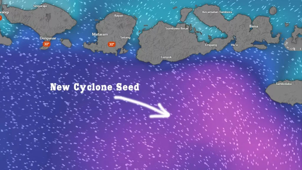
As the year-end weekend continues, atmospheric conditions across Bali show a sharp increase in convective cloud activity. A large buildup of Cumulonimbus clouds over the Bali Strait is expected to move inland from midday. Combined with already saturated soil conditions in Ubud and strong winds along the southern coast, today presents a double risk for weekend travelers and residents.
1. Daily Forecast Summary & RealFeel
Sources: AccuWeather & Weather Underground
| Parameter | Today’s Forecast | Key Notes |
|---|---|---|
| Air Temperature | 25°C – 31°C | Morning hours feel extremely humid and oppressive. |
| RealFeel Temperature | ~37°C | Humidity near 95% significantly increases heat stress. |
| Peak Rain Window | 12:00 – 18:30 WITA | Widespread, high-intensity thunderstorms likely to develop simultaneously. |
| Wind Speed | 30 – 55 km/h | Strong west to northwest winds, most severe in open areas. |
2. Regional Weather Forecast (Key Areas)
Sources: Windy.com & BMKG
- Ubud & Central Bali – HIGH RISK
Sections around Jalan Raya Ubud remain vulnerable following the road collapse on 18 December. Heavy afternoon rainfall may trigger fresh erosion. Traffic on the Desa Mas alternative route is expected to slow to a crawl. - Canggu, Seminyak & Kuta
Short but intense storm cells likely. Watch for standing water that may conceal potholes on shortcut roads. - Uluwatu & Bukit Peninsula
Gusty winds are strong along cliff roads, creating dangerous conditions for motorbike riders. - Bedugul & Kintamani
Persistent heavy rain with thick fog throughout the day. Visibility may drop below 10 meters, especially during afternoon hours.
3. High-Risk Zones and Safety Alerts
Source: BMKG Hydrometeorological Analysis
- Landslide Threat
Primary concern along river cliffs and slopes in Ubud, Gianyar, and Bangli. Soil structure is highly unstable after a week of continuous rainfall. - Falling Trees and Structures
Referencing recent incidents in Puspem Badung, parking under large trees or billboards is strongly discouraged between 13:00 – 17:00 WITA. - Lightning Hazard
Avoid open fields, pools, and exposed areas once dark cloud cover thickens overhead.

4. Maritime and Transport Conditions
Source: Windy.com ECMWF Model
- Wave Height
Indian Ocean swell remains extreme at 4.0 – 5.5 meters. All southern beaches are under a No Swimming advisory. - Fast Boats & Ferries
Sanur–Nusa Penida and routes toward Gili Islands face a high risk of midday cancellations due to strong winds and rough seas. - Flights (DPS – Ngurah Rai Airport)
Possible airborne holding or diversion if storm cells pass directly over the runway during the late afternoon.
5. Practical Guidance for Today
| Situation | Recommended Action |
|---|---|
| Outdoor Activities | Complete outdoor plans before 11:30 WITA. |
| Wildlife Encounters | Heavy rain pushes monitor lizards and snakes into populated areas. Do not provoke; give them space. |
| Driving Conditions | Ensure tires and wipers are in good condition. Roads will be slick with reduced visibility. |
6. Safety Advice for Expats and Tourists in Bali
For Weekend Visitors
Avoid cliffside viewpoints, marine activities, and long-distance driving this afternoon. Storm intensity may escalate quickly with little warning.
For Long-Stay Residents
Monitor local updates closely, especially in Ubud and hill areas. Minor road closures or traffic diversions may occur without prior notice.
Bottom Line
Today’s weather risk is driven by intensity and timing, not duration. Short storms may cause outsized impacts. Conservative planning is strongly advised.
Forecast References
BMKG official warnings and hydrometeorological analysis
Windy.com ECMWF model for wind and swell
AccuWeather RealFeel and storm timing
Weather Underground community stations across Bali


