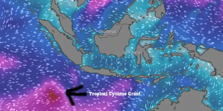
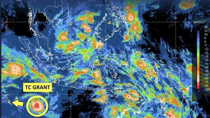
JAKARTA, Indonesia — The Indonesian Meteorology, Climatology, and Geophysics Agency (BMKG) is monitoring a newly formed weather system, Tropical Cyclone Grant, which developed in the Indian Ocean southwest of Sumatra on Tuesday, December 23, 2025. While the storm is currently moving away from the archipelago and is not expected to make landfall, its peripheral effects are forecast to bring moderate ocean swells to parts of Indonesia’s southern coastline in the coming days.
According to the BMKG, Cyclone Grant intensified from a tropical disturbance (formerly designated 93S) into a Category 1 storm approximately 1,000 kilometers from the coast of Lampung. With maximum sustained winds of 35 knots (65 km/h), the system is tracking west-northwestward, further into the open Indian Ocean.
Understanding the Indirect Impact
A primary concern for Indonesia lies in the cyclone’s capacity to generate significant sea swells at a distance. The BMKG has issued warnings for moderately high waves, potentially reaching 1.25 to 2.5 meters (4 to 8 feet), in several southern waterways. Affected areas include:
- Waters west of Lampung
- The southern parts of the Sunda Strait
- Waters south of Java
- The Indian Ocean west of Bengkulu to south of West Java
“Even as it moves away, the cyclone’s circulation energizes the ocean over a wide area,” explained a BMKG forecaster. “This energy translates into waves that can travel long distances, reaching our southern shores and creating hazardous conditions for maritime activities.”
The agency predicts Cyclone Grant will intensify to Category 2 strength within 24 hours, with winds potentially reaching 50 knots (95 km/h), before continuing on a path away from Indonesian territory.
Guidance for Residents and the International Community in Bali
The BMKG has urged communities in coastal areas, particularly fishing and shipping operators, to exercise heightened vigilance and prioritize safety by monitoring official updates. For Bali’s large international community of expatriates and tourists, this forecast carries specific implications.
Key Advisory for Travelers and Residents:
- Maritime Travel: Exercise caution and check with local operators before undertaking sea crossings, especially on southern routes (e.g., the Bali Strait to Java) or planning boat trips, diving, and surfing excursions along Bali’s southern coast (like Uluwatu or Nusa Dua). Ferries may adjust schedules or temporarily suspend services if conditions deteriorate.
- Beach Safety: Swells and stronger-than-usual currents can create dangerous rip tides, even on days with clear skies. Heed any warning flags posted by local lifeguards and avoid swimming in unfamiliar or unprotected areas.
- Stay Informed: The most reliable source for real-time updates is the official BMKG website or their social media account @infobmkg. Following local news outlets like Hey Bali News for translated summaries and context is also recommended.
While Cyclone Grant itself poses no direct threat to Bali’s weather, its ripple effects serve as a seasonal reminder of the island’s dynamic marine environment. As the storm strengthens over the open ocean, a proactive approach to safety ensures that residents and visitors can continue to enjoy Bali’s coastal beauty with respect for the power of nature.
Hey Bali News provides trusted, safety-focused reporting for the island’s international community, translating official information into actionable guidance for daily life.


